Showing 94 items matching creek bed
-
 Federation University Historical Collection
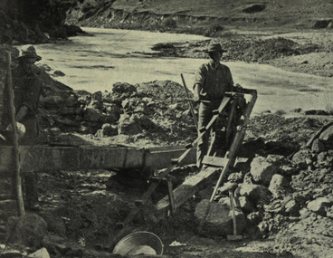
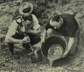
Photograph - Photograph - black and white, Sluicing in a creek bed
... Sluicing in a creek bed...creek bed...Image of a man sluicing in a creek bed. ... bed Image of a man sluicing in a creek bed. Photograph ...Photograph included in book "Victoria: Gold and Minerals" issued by Mines Department Victoria, 1935Image of a man sluicing in a creek bed. victoria, gold mining, prospecting method, sluicing, creek bed, mining, tools, prospecting -
 Whitehorse Historical Society Inc.
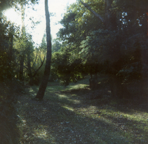
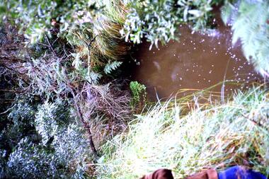
Photograph, Old Creek Bed in Nethercote Homestead Grounds, C.1984
... Old Creek Bed in Nethercote Homestead Grounds...Coloured photo of Old Creek Bed in Nethercote Homestead... Mitcham melbourne Photograph Photograph Old Creek Bed ...Coloured photo of Old Creek Bed in Nethercote Homestead Grounds.nethercote, ian -
 Ringwood and District Historical Society
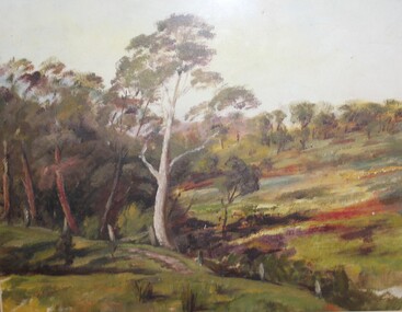
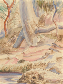
Painting, Winifred Miles, "Creek Bed" - Oil on canvas by Winifred Miles (1884-1944), Undated, later than 1910
... "Creek Bed" - Oil on canvas by Winifred Miles (1884-1944)... Road Ringwood North melbourne Painting "Creek Bed" - Oil ..."Alexander Colquhoun [Herald art critic 1914-1922 and feature writer for the Age 1926-1941] ... took private students in the first decade of the century, and one of these was Winifred Miles, who after her marriage in 1910 lived the remainder of her life in Ringwood. ... (She) began by doing charcoal studies of animals when she was in Balranald, but in later years moved to oils and then watercolours, travelling around Ringwood to find places to paint by means of a pony-driven governess-cart. She won prizes for paintings in the Royal Melbourne Shows." - Hugh Anderson - Ringwood, Place of Many Eagles [p.217].Painting with cardboard border in glass-fronted frame. -
 Nillumbik Shire Council
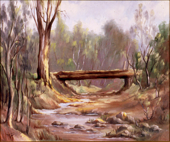
Painting: Yvonne BIRCH (nee BALL), Untitled, c.1984
... of an dry creek bed. Trees line the creek banks and a log bridge... in muted tones of an dry creek bed. Trees line the creek banks ...Oil on canvas board, landscape painting in muted tones of an dry creek bed. Trees line the creek banks and a log bridge crosses the creek bed, perhaps built from the local tree timbers.Lower right, black paint 'Yvonne Ball' -
 Federation University Historical Collection
Photograph - black and white, Panning Off
... creek bed... mining prospecting method creek bed panning gold panning gold pan ...Photograph included in book "Victoria: Gold and Minerals" issued by Mines Department Victoria, 1935Image of two men involved in panning for gold. victoria, gold mining, prospecting method, creek bed, panning, gold panning, gold pan, mining, prospecting, tools -
 Benalla Art Gallery
Watercolour, Eric WILSON, Berowra, 1940
... Watercolour depicting a creek bed with rock... Watercolour depicting a creek bed with rock in the foreground ...Born: Annandale, New South Wales, Australia 1911; Lived and worked: England and France 1937-1940; Died: Sydney, New South Wales, Australia 1946ModernismGift of Mrs E.E. Ledger, 1987Watercolour depicting a creek bed with rock in the foreground. Unframed, hinged taped with two pieces of white tape to cream mat boardRecto: Not signed, not dated, not titledwatercolour, landscape, trees, water, rock, roots -
 Hume City Civic Collection
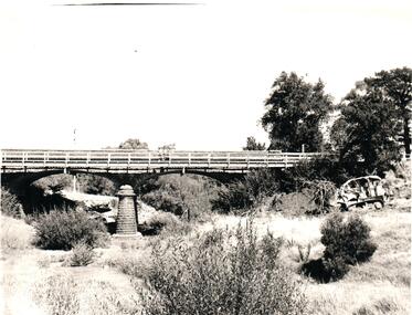
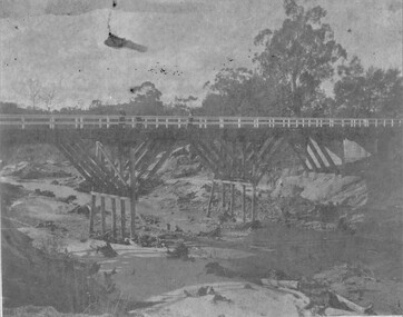
Photograph, 1960s
... bridge which spans a dry creek bed. A bulldozer... bluestone bridge which spans a dry creek bed. A bulldozer ...The two-arched bluestone bridge which spans the Jacksons Creek at the east end of Sunbury township, was built in 1857 and continued to be used as a road bridge on the main Sunbury Road-Macedon Street until the early 1970s when a wider bridge replaced the original bluestone bridge.A black and white photograph of a two- arched bluestone bridge which spans a dry creek bed. A bulldozer is on the riverbank on the RHS of the photograph.bridges, bluestone bridges, jacksons creek, harris, thomas lascelles, macedon street, george evans collection -
 Eltham District Historical Society Inc
Photograph, Cross beam from old timber Main Road bridge over the Diamond Creek, 1992
... Road trestle bridge lying in creek bed. It is downstream from... over the Diamond Creek, 1992 Two colour photographs of old ...Two colour photographs of old cross beam from original Main Road trestle bridge lying in creek bed. It is downstream from the current re-structured bridgebridges, diamond creek, main road, eltham south -
 Greensborough Historical Society
Slide - Photograph, John Ramsdale, Plenty River, upstream from Gorge: Slide 42, 1990s
... Photograph shows creek bed with vegetation, upstream from... creek bed with vegetation, upstream from Plenty Gorge. Part ...Photograph shows creek bed with vegetation, upstream from Plenty Gorge.Part of the John Ramsdale collection of slides and audio visual material.Colour photograph scanned from slide.No caption. Printed maker's mark on slide "Kodak Kodachrome Slide"plenty gorge, plenty river, mernda -
 Stawell Historical Society Inc
Photograph, Delley's Bridge
... Delley's Bridge Halls Gap c1917 showing Creek Bed. Similar... showing Creek Bed. Similar to Photo 1242-1 Transport ...Delley's Bridge Halls Gap c1917 showing Creek Bed. Similar to Photo 1242-1 transport -
 Surrey Hills Historical Society Collection
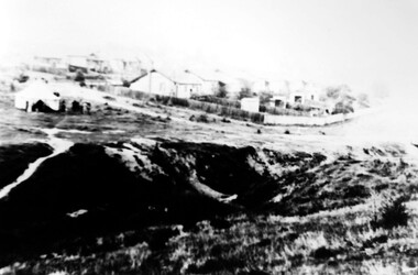
Photograph, Back Creek (later South Surrey Park), c 1936, 1936
... the creek bed.... the creek bed. This photo was taken at the opening of the footbridge ...This photo was taken at the opening of the footbridge by Sir Winston Dugan in 1936.South Surrey Park was developed on land which had been the property of the Kleinert family. Their land extended from Union Road to Essex Road. They ran horses, ducks and fowls and Emily Kleinert grew flowers. Alan Holt research: Lot 6 was sold to Martin Klienert by Karl Richter in 1860 together with a portion of another adjacent lot. From 1860-1885 Martin worked it as a market garden leasing some land for grazing when it was not required for gardening. He died in 1898. In a formal document, William declared he was the son of Martin "who purchased land in 1860, died in 1898 and the land has been continually occupied by father and family since. It has been cultivated as a market garden; when not being used for gardening it was let for cultivation and grazing." William died in 1939 and the property passed to his sons Martin and Ernest. The family sold the land to the Camberwell Council in the 1950s.This photo is significant as it shows the transition from rural to urban land use in Surrey Hills.Black and white photo taken in the area later known as South Surrey Park. Back Creek is in the foreground. There is a tent on the LHS and approximately 7 houses which front Verdun Street. Some of their backyards face onto the open space along the creek bed.parks and reserves, creeks, south surrey park, civic occasion, official events, back creek, verdun street, 1936, kleinert family, sir winston dugan, topography -
 Surrey Hills Historical Society Collection
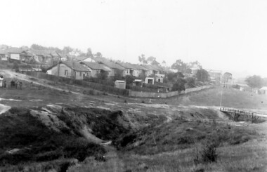
Photograph, Back Creek (later South Surrey Park), c 1936, 1936
... the creek bed.... the creek bed. This photo was taken at the opening of the footbridge ...This photo was taken at the opening of the footbridge by Sir Winston Dugan in 1936.South Surrey Park was developed on land which had been the property of the Kleinert family. Their land extended from Union Road to Essex Road. They ran horses, ducks and fowls and Emily Kleinert grew flowers. Alan Holt research: Lot 6 was sold to Martin Klienert by Karl Richter in 1860 together with a portion of another adjacent lot. From 1860-1885 Martin worked it as a market garden leasing some land for grazing when it was not required for gardening. He died in 1898. In a formal document, William declared he was the son of Martin "who purchased land in 1860, died in 1898 and the land has been continually occupied by father and family since. It has been cultivated as a market garden; when not being used for gardening it was let for cultivation and grazing." William died in 1939 and the property passed to his sons Martin and Ernest. The family sold the land to the Camberwell Council in the 1950s.This photo is significant as it shows the transition from rural to urban land use in Surrey Hills.Black and white photo taken in the area later known as South Surrey Park. Back Creek is in the foreground. There is a tent on the LHS and approximately 7 houses which front Verdun Street. Some of their backyards face onto the open space along the creek bed.parks and reserves, creeks, south surrey park, civic occasion, official events, back creek, verdun street, 1936, kleinert family, sir winston dugan, topography -
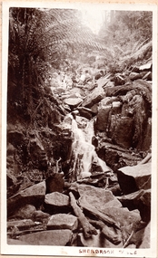 Southern Sherbrooke Historical Society Inc.
Photograph, Sherbrooke Falls
... of large rocks in and around creek bed. Ferns grow up sides.... Huge amount of large rocks in and around creek bed. Ferns grow ...Photo of the falls in Sherbrooke Forest. Huge amount of large rocks in and around creek bed. Ferns grow up sides of banks. Low volume of water indicates dry season. At the top of the falls a man sits with another person who appears to be a woman. c.1920. -
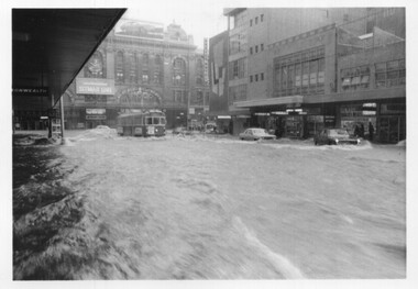 Melbourne Tram Museum
Photograph - Set of 5 black and white - Elizabeth St flood, Peter Duckett, 17-2-1972
... Market and the former creek bed of Elizabeth Street acting... and the former creek bed of Elizabeth Street acting as a drain. Cars ...Shows the impact of a major rain event near the Victoria Market and the former creek bed of Elizabeth Street acting as a drain. Cars floated and trams were damaged.Yields information about a major rain event in Elizabeth St during 1972 and the impact it had on vehicles and tramway operations.Set of five black and white photographs of major flooding in Elizabeth St 17-2-1972. Copied by the donor from negatives provided by the photographer.floods, elizabeth st, tramways, events, trams, melbourne -
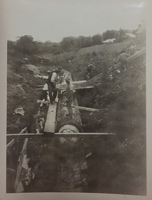 Kew Historical Society Inc
Photograph, City of Kew, Cecil Street Drain, 1936
... Public works. Men at work in the creek bed of Connor's.... Men at work in the creek bed of Connor's Creek in Kew, while ...An original photograph donated to the Kew Historical Society by the City's Engineering Department following the amalgamation of Kew into the City of Boroondara. While not all of the photographs are of Studley Park, Kew or East Kew, each photo provides a fine snapshot of the work of local government engineering departments of the period. They reveal they types of labour conducted, the techniques used and the equipment and machinery in the possession of the local government authority. Historic and rare photograph of major public works in Kew in the 1930s.Public works. Men at work in the creek bed of Connor's Creek in Kew, while constructing the underground drain. Connor's Creek was one of the two main tributaries of the Yarra River in Kew. It originated somewhere near the grounds of Genazzano FCJ College. The barrel drain was finally completed in 1941 at a cost of £14,000. Inscription on reverse: "City of Kew / Cecil st drain / November 1936". city of kew, city of kew (engineering department), engineering, connor's creek (kew) -
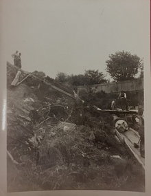 Kew Historical Society Inc
Photograph, City of Kew, Cecil Street Drain, 1936
... Public works. Men at work in the creek bed of Connor's.... Men at work in the creek bed of Connor's Creek in Kew, while ...An original photograph donated to the Kew Historical Society by the City's Engineering Department preceding the amalgamation of Kew into the City of Boroondara. While not all of the photographs are of Studley Park, Kew or East Kew, each photo provides a fine snapshot of the work of local government engineering departments of the period. They reveal they types of labour conducted, the techniques used and the equipment and machinery in the possession of the local government authority. Historic and rare photograph of major public works in Kew in the 1930sPublic works. Men at work in the creek bed of Connor's Creek in Kew, while constructing the underground barrel drain. Connors Creek was one of the two main tributaries of the Yarra River in Kew. It originated somewhere near the grounds of Genazzano FCJ College. The barrel drain was finally completed in 1941 at a cost of £14,000. Inscription on reverse: "City of Kew / Cecil st drain / November 1936". public works (kew), roadmaking, engineering, city of kew (engineering department), connor's creek (kew), cecil street drain -
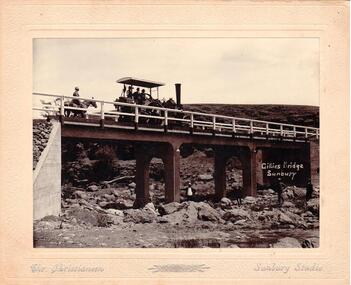 Hume City Civic Collection
Photograph
... the creek bed. The mounting is cream, 2 cm wide with silver writing... standing across the creek bed. The mounting is cream, 2 cm wide ...Chris. Christiansen was a barber in Sunbury. He also ran a photographic studio from 1892 - 1916. His business was situated on the corner of Evans and Brook Streets. The Gillies Bridge is Situated on the Wildwood Road just off the Lancefield Road.A mounted sepia photograph of the Gillies Bridge at Sunbury. Across the bridge there are three men on a steam roller and one man behind on horseback. There are four men standing across the creek bed. The mounting is cream, 2 cm wide with silver writing under the photo. Cream mounting - 2 cm wide with silver inscriptionsGILLIES BRIDGE / SUNBURY / CHR. CHRISTIANSEN /gillies bridge, wildwood bridge, bridges, horses, christiansen, chris, photographers, animals, steam rollers, sunbury, men, clothing and dress, george evans collection -
 Surrey Hills Historical Society Collection
Photograph, Boys who later joined the 1st Surrey Hills scout troop, 1909
... in the eroded creek bed, called 'The Alps', of Back Creek opposite... of scrub in the eroded creek bed, called 'The Alps', of Back Creek ...1st Surrey Hills was the 3rd troop formed in Victoria. Harrison Buchanan was not old enough to join and for a time was the 'troop mascot' as the cubs had not been formed at this time. He later became the troop's 2nd Scoutmaster. Doug Jeffries lived at 12 Vincent Street. Alex Lucas was the son of the draper in Canterbury Road. Our documentation variously gives the date as 1901 or 1909.Six boys are pictured against a backdrop of scrub in the eroded creek bed, called 'The Alps', of Back Creek opposite Wattle Park. Three of them are identified as: Harrison Buchanan (with the stave), Doug Jeffries on the LHS and Alex Lucas next to him.Black and white photo measuring L 24.5 cm x H 17.4 cmback creek, 1st surrey hills scout troop, scouts, harrison buchanan, alex lucas, doug jeffries, childhood and youth, topography -
 Robin Boyd Foundation
Document - Script, Robin Boyd, The Flying Dogtor. Episode 9 The Helping Hand, 1963
... and the Dogtor could not loosen the logs that were blocking the creek bed... not loosen the logs that were blocking the creek bed. Because ...Elvis resumed pouring the rainmaking powder onto the clouds and the Dogtor could not loosen the logs that were blocking the creek bed. Because the Dogtor had been so nice to Elvis, in the end, Elvis helped the Dogtor dislodge the logs and the flood subsided. But Crafty Carson Carpetbag and Old Man Redback lay waiting, scheming, planning their next nasty surprise.The Flying Dogtor" series was broadcast on Australian Television Network (later becoming the Seven Network) between February and April 1964 (see item D254 for schedule).Typewritten, carbon copy, foolscap, 2 pagesthe flying dogtor, robin boyd, crawford productions, manuscript -
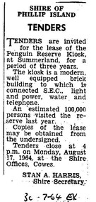 Phillip Island Conservation Society Inc.
Work on paper - Photocopy of newspaper cutting, Wonthaggi or Powlett Express newspaper, "SHIRE OF/ PHILLIP ISLAND/ TENDERS", 30.7.1946
... was actually raised from creek bed adjacent to the bitumen area... was actually raised from creek bed adjacent to the bitumen area ...Shire of Phillip Island managed the Phillip Island Penguin Parade during this era, and made several improvements for visitors including the building of a kiosk for food and beverage and some souvenirs. The building was located on a bitumen area at the base of the hill along with a brick toilet block. The area was actually raised from creek bed adjacent to the bitumen area, with Little Penguin rookery either side. The Shire tendered out the contract for the running of this kiosk on a 3 yearly basis.This small public notice from a Wonthaggi newspaper at a time when no local newspaper was being published on Phillip Island, marks the time when the Shire of Phillip Island began to increase provision of tourist facilities at the Penguin Parade. The number of visitors being 100,000 for the previous year is also an excellent indication of the popularity of the Penguin Parade. The listing of infrastructure available to the building is useful.Photocopy of Public Notice, Rectangular. Single collumn with heading, sub-heading, 5 paragraphs of text and Name and position of Shire Secretary. Black and white."30-7-64 EX" Meaning: 30.07.1964. Powlett Express newspaper.phillip island penguin parade, shire of phillip island, penguin parade kiosk, tender process, penguin parade visitor numbers, sec state electricity commission, stan harris phillip island shire secretary -
 Glenelg Shire Council Cultural Collection
Photograph - Photograph -Bridge and Creek, n.d
... with wooden railings and supports, taken from bed of creek. Banks... of bridge with wooden railings and supports, taken from bed of creek ...Sourced from Casterton Town Hall (former Shire of Glenelg)Coloured photographs a and b. Side view of bridge with wooden railings and supports, taken from bed of creek. Banks of creek eroded. Identifying numbers 7304 a, b -
Glenelg Shire Council Cultural Collection
Photograph - Photograph -Bridge, n.d
... , three wooden supports, taken from bed of creek. Banks of grass..., three wooden supports, taken from bed of creek. Banks of grass ...Sourced from Casterton Town Hall (former Shire of Glenelg)Coloured photograph. Side view of bridge, wooden rails, three wooden supports, taken from bed of creek. Banks of grass, narrow walking track along right side of creek. -
 Falls Creek Historical Society
Photograph - Falls Creek Huette
... to be carried to the lodge from the main road. The first Falls Creek... to be carried to the lodge from the main road. The first Falls Creek ...The Falls Creek Huette was created as a result of the ideas, support and persistence of Charles Anton, Founder and First President of the Australian Alpine Club. It opened on the Queen’s Birthday weekend 1963, the same day as the Perisher Huette Work on prefabricating the walls commenced in Melbourne at the start of March 1963. Digging of the foundation trenches commenced on site on 19 March 1963. When the first snow fell on 20 March 1963 some of the construction was temporarily under snow. Fortunately, the site was not buried for long, although the deep mud that developed meant that every sheet of plaster along with all fittings and furniture had to be carried to the lodge from the main road. The first Falls Creek Huette had 14 beds in the bedrooms and an overflow area that could accommodate 6 more persons. It served the Australian Alpine Club until it was sold in 1971 and a much larger lodge was built on another site.These images are significant because they document the construction of an important building at Falls Creek, VictoriaImages from display at Falls Creek Museumfalls creek huette, falls creek lodges, charles anton, australian alpine club -
 Eltham District Historical Society Inc
Film - Video (VHS), Nillumbik Shire Council, The Nillumbik Story, 1996
... , keeping cattle out of the creek bed to improve the quality..., keeping cattle out of the creek bed to improve the quality ...PART 1 – NILLUMBIK (00:00-07:17) Opening features various scenes around Nillumbik Shire. For 40,000 years Nillumbik was the home of the Wurundjeri people. Robert Hoddle gave the district its name. Jock Ryan, then president of Nillumbik Historical Society discusses the names Nillumbik and Diamond Creek. In the late 1830s white occupation began with gold found in Warrandyte in 1851 and 12 years later at Diamond Creek -the Diamond Reef which led to the Caledonian gold rush. Jock Ryan discusses the Diamond Creek mine, which was thriving until it burnt out in 1915. Large numbers of workmen moved into area in late 1870s to construct the Maroondah Aqueduct. With growing population of Melbourne, the nearby Yan Yean system had severely disrupted the flow of the Plenty River, forcing the closure of three flour mills there. The aqueduct came to the rescue carrying water 66km from Healesville to Preston. When the Diamond Creek gold mine burnt down the local economy suffered but fruit growing industry had already been established and Diamond Creek became a thriving fruit growing centre. Interview with Jack Powell, a long-time fruiterer at St Andrews market, his family had lived in the area for a hundred years, 3 to 4 generations, “a lot of hard work”. By the time the railway arrived fruit growing was no longer competitive. The railway brought the city closer and day trippers. The Green Wedge separates the shire from the more densely developed neighbours such as Whittlesea, Doncaster, Templestowe, Bulleen and Greensborough. Population at the time (1996) was 19,000 but links to the past remain strong. Mudbrick houses along the Heritage Trail The saving of Shillinglaw Cottage from demolition in 1963 and relocation brick by brick. PART 2 – ENVIRONMENT (07:18-14:44) Peter Brock (with Bev Brock in background) at St Andrews market discusses his childhood growing up in the district and the environment and the values it instilled upon him and his own family. The Brocks have been in the district since the 1860s. Nillumbik Shire responsible for managing three catchment areas; Diamond Creek, Arthurs Creek and Watsons Creek. Follows the course of the Diamond Creek commencing in Kinglake through the district to its confluence with the Yarra River at Eltham at Eltham Lower Park. Highlights Eltham Lower Park community revegetation program and the newly constructed (1996) viewing platform built of new and recycled timbers at the confluence of the Diamond Creek and Yarra River. Also featured are outdoor recreation on the river and at Eltham Lower Park including the Diamond Valley miniature railway. Sugarloaf reservoir and recreational activities and fishing. Aerial view of Memorial Park and Shire of Eltham War Memorial tower at Garden Hill, Kangaroo Ground. Significant tourism opportunities for the shire with 3 million potential day-trippers in metropolitan Melbourne. Council and community working together to find a way to promote the shires natural and artistic assets. At Arthurs Creek, the Brock family and neighbours working together to take care of their waterway. Peter Brock’s uncle, Sandy Brock talks about environmental management and the Arthurs Creek Landcare group and actions to eradicate blackberry problem. Having previously planted Cypress rows they are replacing them with indigenous species to improve the water supply, keeping cattle out of the creek bed to improve the quality downstream flowing into the Yarra. Eltham East Primary School Band playing “All things bright and beautiful” merges into scenes of the bushland sanctuary set aside by the school in 1980 with unidentified teacher discusses the sanctuary and their education program and school children’s comments. Plight of a family of Wedgetail eagles nesting in the path of a developer’s bulldozer at North Warrandyte and actions to save their nesting areas. PART 3 – ARTS (14:45-22:00) Arts and Jazz festival at Montsalvat featuring interviews with Sigmund Jorgensen discussing Montsalvat and its principles. Also Matcham Skipper. Clifton Pugh’s funeral at Montsalvat and his legacy at Dunmoochin near Cottlesbridge with artists in residence, at the time, Chicago artist Charles Reddington who discusses the benefits of the experience. An unidentified female artist also talks about the program and why people are drawn to the area. Unidentified man on street talking about the amount of talent in the area, artists, poets, musicians, authors. Artist Ming Mackay (1918-2009) interviewed talking about the people she mixes with on “the Hill”. Works of local artists are displayed Eltham Library Community Gallery and Wiregrass gallery with a new coffee shop at the Wiregrass making it an even more popular destination. Music at St Andrews Hotel (may be a little bit country) and the Saturday market where likely to hear anything. Sellers and patrons at the market asked about what attracts them to the market and where they came from. Scenes of poets/authors giving readings. CREDITS Music by John Greenfield from the CD Sweet Rain “The Snow Tree”, Uncle Music UNC 2001 Cameras - David Mirabella and Peter Farragher Editor – Olwyn Jones Written and Produced by Jason Cameron A Jason Cameron Proction for Nillumbik ShireProvides a record of the relatively newly created Shire of Nillumbik at the time and the features and attactions of the shire in its people arts, culture and environmentVHS Cassette (two copies) Converted to MP4 file format 0:22:00, 1.60GBvideo recording, arthurs creek, arthurs creek landcare group, artists, artists in residence, arts, arts festival, authors, blackberry, brock family, bulldozer, bulleen, bushland sanctuary, caledonian gold rush, charles reddington, clifton pugh, cottlesbridge, cypress rows, developer, diamond creek, diamond creek mine, diamond reef, diamond valley miniature railway, doncaster, dunmoochin, education program, eeps, eltham, eltham east primary school, eltham east primary school band, eltham library community gallery, eltham lower park, environment, fishing, flour mill, fruit growing, fruiterer, garden hill, gold mining, green wedge, greensborough, heritage trail, hurstbridge railway line, jazz festival, jock ryan, kangaroo ground, kangaroo ground tower, kinglake, maroondah aqueduct, matcham skipper, memorial park, ming mackay (1918-2009), montsalvat, mudbrick houses, music, musicians, nesting area, nillumbik historical society, nillumbik shire, north warrandyte, old timer, orchards, peter brock, plenty river, poets, population, recreation, recreational activities, revegetation, robert hoddle, sandy brock, shillinglaw cottage, shire of eltham war memorial, sigmund jorgensen, st andrews hotel, st andrews market, sugarloaf reservoir, templestowe, the hill, tourism, viewing platform, warrandyte, water catchment area, watsons creek, wedgetail eagle, whittlesea, wiregrass gallery, wurundjeri, yarra river, jack powell -
 The Beechworth Burke Museum
Geological specimen - Actionlite and Pyrite
Actinolite is usually found in metamorphic rocks, such as contact aureoles surrounding cooled intrusive igneous rocks. It also occurs as a product of the metamorphism of magnesium-rich limestones. Pyrite is usually found with other sulfides or oxides in quartz veins, sedimentary rock, and metamorphic rock, as well coal beds, and as a replacement mineral in fossils. Actinolite is an amphibole silicate mineral. It is named after the Greek word "aktinos" meaning “ray” in allusion to the mineral's fibrous nature. Fibrous actinolite is a type of asbestos and was once mined along Jones Creek at Gundagai, New South Wales. Pyrite or "Fool's Gold" is the most common sulfide mineral. It is named after the Greek "pyr" meaning "fire" because it can be used to create sparks needed for a fire if struck against metal or a hard surface. Due to its gold colour, pyrite can be mistaken for gold and often forms alongside it, causing small amounts of gold to be present in rocks containing pyrite. Most importantly, pyrite is an ore of gold. Pyrite is sometimes used as a gemstone but is not great for jewellery as it easily tarnishes. In some fossils of ammonites – shelled cephalopods that died ~66 million years ago – pyrite also replaces the shell. This specimen is part of a larger collection of geological and mineral specimens collected from around Australia (and some parts of the world) and donated to the Burke Museum between 1868-1880. A large percentage of these specimens were collected in Victoria as part of the Geological Survey of Victoria that begun in 1852 (in response to the Gold Rush) to study and map the geology of Victoria. Collecting geological specimens was an important part of mapping and understanding the scientific makeup of the earth. Many of these specimens were sent to research and collecting organisations across Australia, including the Burke Museum, to educate and encourage further study. A small-medium-sized solid specimen with the minerals actinolite (dark green fibrous) and pyrite (brassy) with shades of brown, black/grey, and white. Actinolite is an amphibole mineral in the tremolite-actinolite series of calcium, magnesium, and iron silicates. Pyrite is an iron disulfide mineral.geological specimen, geology, geology collection, burke museum, beechworth, indigo shire, geological, mineralogy, pyrite, actinolite, victoria, sewyln, alfred selwyn -
 Kiewa Valley Historical Society
Photograph - Building of Myrtleford Ski Club
Myrtleford Ski Club is a non-commercial, family friendly club. It was one of the earliest lodges to be built at Falls Creek and was one of the earliest ski clubs formed and celebrated its 75th anniversary in 2013. In 1949, Myrtleford Ski Club obtained permission for occupancy and began planning the MSC Lodge. There were only three other huts on the mountain, Bogong Ski Club in an old Army hut, Skyline as the Ski Club of Victoria lodge and the Albury Ski Club lodge. The lodge was built mostly from donated materials. The basement was dug out and lined with stone from the Ruined Castle area, timber was cut (using cross-saws) from the Walpole properties and was milled then carted up to Falls Creek on either the Walpole or Calvert trucks. The iron on the roof was originally a tobacco kiln on Billy McNamara's property. The lodge has undergone many improvements over the years including a second storey added in the 1950’s, updating of accommodation, shower and toilet facilities to meet the changing needs of members. The lodge now caters for 38 people in a variety of shared rooms from two to eight beds per room. Toilet and shower facilities are also shared. The club has a Lodge Managers for the winter season. Myrtleford Ski Lodge was one of the earliest ski lodges built in the Falls Creek area in 1938. It is an excellent example of early sporting and community activities in the Upper Kiewa Valley area. Photograph shows family members, including women, involved in the construction.Sepia photograph of the building of the Myrtleford Ski Club about 1948Handwritten on the back of photograph in black pen - Building Myrtleford Ski Club (about 1948) Stamped on back of photograph - 6 2511myrtleford ski club, skiing, snow sports, victorian alps, falls creek -
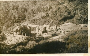
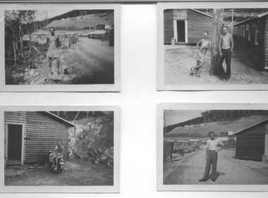 Kiewa Valley Historical Society
Photograph - 8 Black and white photographs - SECV, Unknown
All eight photographs have been taken at a workmen's camp erected by the State Electricity Commission to house workmen during the construction of the Kiewa Hydro Electric Scheme. These were established in close proximity to various work centres - Junction Camp at Bogong Village, three camps at Mt. Beauty, West Kiewa, Clover Dam and Clover Flat, Howman's sawmill and Howman's Gap, Rocky Valley, Langford's Gap, Pretty Valley, Mountain Creek and Big Hill. These photos have not been identified as to which camp they are taken but typical of the type of accommodation for wages personnel. They followed a general design and layout. There was a mess and recreation hall as well as a building for general trading and postal facilities (this conducted by proprietors of trading stores in Mt. Beauty and Bogong). Originally the rooms accommodated 2 men but later there was a demand for single rooms - the floor size then being 10 feet x 8 feet and furnished with a bed, small table and chair and cupboard with hanging space. The first camps were erected in 1940 and the last was removed in 1962.These photographs are of historical significance as they show the type of accommodation provided for wages personnel working on the Hydro Electric Scheme between 1940 and 1960.Eight small black and white photographs of unknown person and workmen's camp.All photos have been stamped on the back - Two "965U" in red, four "S80 " in green (indistinct) and two "141" in red.workmen's camps, kiewa hydro electric scheme, accommodation, secv, camps on kiewa hydro electric scheme, west kiewa -
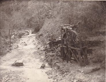 The Beechworth Burke Museum
Postcard, 1920
... of Rechabite Reef (locality) workings. / Shaft in bed of creek. Wheel... of Rechabite Reef (locality) workings. / Shaft in bed of creek. Wheel ...This postcard depicts the set-up of an abandoned gold mine. This includes a water wheel and other mining implements next to a creek. The postcard inscription indicates that this image is of the remains of the Wallaby Reef battery and water wheel. Wallaby Reef was discovered in 1864, and a prospecting claim established a four head battery and water wheel. Quartz was mined there, with gold also discovered at this location at a later date. By 1878 the mine was no longer resulting in rich deposits, this resulted in the miners moving their search for gold closer to the river where they were able to access more gold. This was in approximately 1879. In 1882 a rich deposit was found. In 1908 the battery was closed, and the mine finished. This photo was taken in 1920 and shows the deterioration of the site since its closure. Gold mining was crucial to the development of the Beechworth area. It has strong research and historical value because the clarity of the photo shows all the minute details of the mining equipment. The text on the back also indicates the mine is the Wallaby Mine, which was used for 45 years to find gold and quartz. Therefore, due to the location being quickly abandoned, this site is a rich location for historical study on gold mining during the 1900s. It can provide important information on the types of tools utilised and the impact of the mining on the environment.Black and white postcard photograph on card.8169 Be / Also near Wallaby Reef Workings / Relics of Rechabite Reef (locality) workings. / Shaft in bed of creek. Wheel used to drive sheadd (?) / stamp battery too I believe near B'worth 1920?beechworth, mining, gold mining, quartz mining, wallaby reef mine, mine battery head -
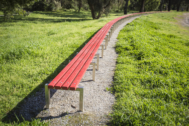 Nillumbik Shire Council
Public Art: Susie KUMAR & Naomi KUMAR, Benchmark (Location: Conventry Oval, Elizabeth Street, Diamond Creek), 1997
1996 Nillumbik Art in Public Places Award (installed late 1997). A biennial program that ceased in 2007. The program commissioned artists to make and install public art in various sites around the Shire. Award judges that year were Tony Trembath and artist Peter D. Cole. Susie Kumar has a Bachelor of Landscape Architecture degree from RMIT and Naomi Kumar has a Bachelor of Fine Art in photography degree from VCA. The Kumar sisters designed the sixty meter gently curving bench in response to the topography of the site, Conventry Oval. The sculpture is designed to describe the boundary between the formal oval and the natural creek bank and a considered relationship to the bike track and the river. It forms a link between the activities and aesthetics of its environment. The work is a comical interpretation of the utilitarian public bench. From a distance the bright red runners (the colour of the local football team's stripe) appear to float about the surrounding green. One end of the work is straight and finished. The other remains 'unfinished' hence allowing for the concept of unlimited extension. The 'legs' (steel hurdles) are arranged with a sense of movement and rhythm in sympathy with the activities happening around the work and with the stands of trees in he background. 'Benchmark' also serves as a functional purpose; providing a choice of places to sit to watch action on the oval. Stainless steel, timber (Victorian Ash) and red enamel paint. Sixty meter long red bench that gently curves in response to Conventry Oval. Bolted on top of evenly spaced stainless steel hurdles, four rows of timber runners are joined to provide unbroken continuous lengths. The bench stands on a framed bed of crushed rock (Lilydale topping).N/Abench, sport, wood, victorian ash, stainless steel, public art, ekphrasis2017 -
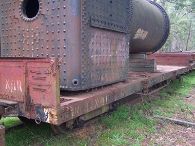 Puffing Billy Railway
Equipment - 103 NQR - Open Medium Truck, 16/12/1909
The NQRs were the standard Medium open goods wagon. Generally the sides and ends were removable thus providing a totally flat truck. Three long drop-down doors formed the sides thus allowing easy loading and unloading. 218 of these goods vehicles were built between 1898 and 1914 ? numbered 1 - 218. Originally, these wagons carried the code letter R as they were built with sides and ends. They later had the R removed. Unlike the Broad Gauge, VR's 2 ft 6 in (762 mm) narrow gauge network never had four-wheeled wagons (aside from a handful of trolleys). Because of this, a single design of open wagon emerged and this was the only type of wagon ever used on these lines. This was the NQR class, a wagon with the same length and loading capacity as a Broad Gauge four-wheeled open wagon to make transferring freight between the gauges easier. The wagons, numbered 1 through 218, were built between 1898 and 1914. The wagons used the same underframe as most other non-locomotives on the VR Narrow Gauge. Letters and numbers were originally painted only on the end bulkheads and doors, both of which could be removed as traffic dictated, and this made wagon identification difficult until the decals were transferred to the underframes of each wagon In the 1910s some NQRs were provided with removable wood and steel frameworks with canvas roof canopies and side curtains, and internal seating to supplement the rest of the passenger stock during busy holiday periods. Puffing Billy has re-created these for emergency capacity. Five more NQRs, numbered 219-223, were built between 1990 and 1992 initially for passenger use so were fitted with the removable frames In the 1960s the Puffing Billy Railway added grids in the floor of some to enable them to be used to drop ballast on the track where needed. Vehicle Length 25 feet 2 inches ( 7671 mm) Coupled Length 27 feet 4 inches (8330 mm) Width 6 feet 3 inches (1905 mm) Weight 5 tons Capacity 11 tons Built 1898 - 1915 (1992) Number Built 218 (223) In use 14 To be restored 6 103 NQR - Open Medium Truck 16/12/1909 NWS Built new Vehicle Length 25 feet 2 inches ( 7671 mm) Coupled Length 27 feet 4 inches (8330 mm) Width 6 feet 3 inches (1905 mm) Weight 5 tons Capacity 11 tons Built 1898 - 1915 (1992) Number Built 218 (223) In use 14 To be restored 6 VR Service History *NQR 103.VA - 16/12/1909 NWS Built new - / /1926 - To NQ 103.VA - Puffing Billy Service History or Notes Untrafficable at ClematisHistoric - Victorian Railways - Narrow Gauge Rolling Stock - NQR Open Medium TruckA large rectangualr open good wagon, with removable sides and ends creating a flat-bed. There are three long drop-down sides and eight narrow guage wheels. The wagon is 7671mm long and 1905mm wide with steel couplings at either end. The wagon is painted crimson (faded) with the words '103 NQR' stenciled in white at both ends. 103 NQRpuffing billy railway, pbr, rolling stock , 103 nqr - open medium truck, victorian railways, narrow gauge rolling stock, nqr wagon